Log in
All resources
Create a design
864 Free Images of Gemeente Musea
gemeente atlas van nederland - south holland
1860s maps of south holland
gemeente atlas van nederland - north holland
1860s maps of north holland
media from regionaal archief alkmaar
19th-century maps of rotterdam
nieuwkoop in the 19th century
bodegraven-reeuwijk in the 19th century
hoeksche waard in the 19th century
drawings by pieter van loo in the beeldcollectie van de gemeente haarlem
gemeente atlas van nederland - south holland
1860s maps of south holland
gemeente atlas van nederland - south holland
1860s maps of south holland
gemeente atlas van nederland - south holland
old maps of gorinchem
gemeente atlas van nederland - south holland
1860s maps of south holland
gemeente atlas van nederland - south holland
maps of hei- en boeicop
maps of utrecht (city) city walls
old maps of utrecht (city)
gemeente atlas van nederland - north holland
maps of egmond aan zee
gemeente atlas van nederland - south holland
1860s maps of south holland
gemeente atlas van nederland - north brabant
maps of putte, netherlands
gemeente atlas van nederland - south holland
1860s maps of south holland
gemeente atlas van nederland - north holland
maps of broek in waterland
gemeente atlas van nederland - north holland
maps of jisp
gemeente atlas van nederland - north holland
maps of beets, north holland
media from regionaal archief alkmaar
sint pancras
media from regionaal archief alkmaar
egmond-binnen
media from regionaal archief alkmaar
sint pancras
gemeente atlas van nederland - south holland
1860s maps of south holland
drawings by pieter jansz. saenredam in the beeldcollectie van de gemeente haarlem
pieter jansz. saenredam
drawings by pieter van loo in the beeldcollectie van de gemeente haarlem
pieter van loo
gemeente atlas van nederland - south holland
maps of zoeterwoude
gemeente atlas van nederland - south holland
maps of lange ruige weide
maps of aa en hunze
anloo
gemeente atlas van nederland - north holland
maps of bergen, north holland
gemeente atlas van nederland - south holland
1860s maps of south holland
media from regionaal archief alkmaar
maps of texel
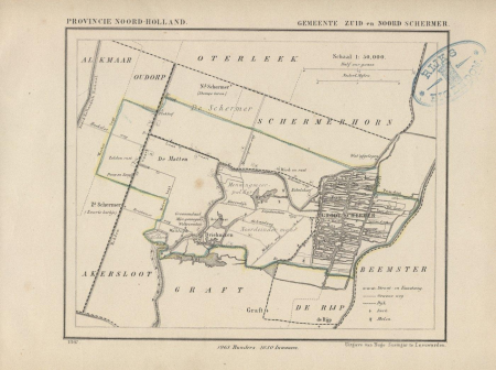
gemeente atlas van nederland - north holland
maps of schermer
gemeente atlas van nederland - south holland
1860s maps of south holland
gemeente atlas van nederland - south holland
1860s maps of south holland
gemeente atlas van nederland - north holland
maps of bussum
gemeente atlas van nederland - friesland
19th-century maps of friesland
gemeente atlas van nederland - south holland
1860s maps of south holland
gemeente atlas van nederland - south holland
1860s maps of south holland
gemeente atlas van nederland - south holland
1860s maps of south holland
drawings by pieter jansz. saenredam in the beeldcollectie van de gemeente haarlem
pieter jansz. saenredam
gemeente atlas van nederland - limburg
maps of tegelen
gemeente atlas van nederland - south holland
old maps of brielle
gemeente atlas van nederland - south holland
19th-century maps of rotterdam
gemeente atlas van nederland - south holland
19th-century maps of rotterdam
gemeente atlas van nederland - south holland
1860s maps of south holland
gemeente atlas van nederland - north holland
old maps of hoorn, north holland
gemeente atlas van nederland - north holland
old maps of hoorn, north holland
gemeente atlas van nederland - north holland
19th-century maps of den helder
gemeente atlas van nederland - north holland
old maps of heemstede, north holland
gemeente atlas van nederland - south holland
old maps of gouda
gemeente atlas van nederland - north holland
maps of sint maarten, north holland
media from regionaal archief alkmaar
maps of heiloo
19th-century maps of south holland
netherlands in the 1860s
media from regionaal archief alkmaar
maps of wieringerwaard
media from regionaal archief alkmaar
maps of barsingerhorn
media from regionaal archief alkmaar
maps of heerhugowaard
media from regionaal archief alkmaar
broek op langedijk
media from regionaal archief alkmaar
maps of wieringen
media from regionaal archief alkmaar
winkel, north holland
19th-century maps of south holland
maps of veur
collection cartographic documents from het utrechts archief
gemeente atlas van nederland - utrecht
gemeente atlas van nederland - south holland
1860s maps of south holland
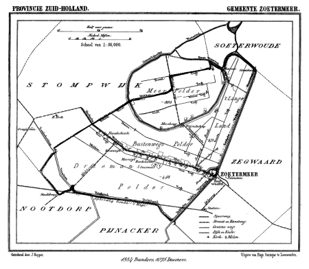
gemeente atlas van nederland - south holland
maps of zoetermeer
gemeente atlas van nederland - north holland
egmond-binnen
gemeente atlas van nederland - south holland
1860s maps of south holland
gemeente atlas van nederland - south holland
19th-century maps of rotterdam
media from regionaal archief alkmaar
maps of barsingerhorn
gemeente atlas van nederland - south holland
1860s maps of south holland
gemeente atlas van nederland - south holland
maps of groot-ammers
gemeente atlas van nederland - south holland
1860s maps of south holland
gemeente atlas van nederland - south holland
1860s maps of south holland
gemeente atlas van nederland - south holland
1860s maps of south holland
gemeente atlas van nederland - south holland
1860s maps of south holland
gemeente atlas van nederland - south holland
1860s maps of south holland
gemeente atlas van nederland - south holland
19th-century maps of rotterdam
gemeente atlas van nederland - south holland
maps of zegwaart
gemeente atlas van nederland - south holland
maps of nieuwenhoorn
gemeente atlas van nederland - south holland
maps of zoeterwoude
gemeente atlas van nederland - north holland
old maps of amsterdam
gemeente atlas van nederland - north holland
old maps of alkmaar
gemeente atlas van nederland - south holland
polytechnische school te delft
gemeente atlas van nederland - south holland
1860s maps of south holland
gemeente atlas van nederland - south holland
1860s maps of south holland
gemeente atlas van nederland - south holland
maps of waddinxveen
gemeente atlas van nederland - south holland
1860s maps of south holland
media from regionaal archief alkmaar
old maps of schagen
gemeente atlas van nederland - north brabant
maps of willemstad, north brabant
history of alphen aan den rijn
maps of aarlanderveen
gemeente atlas van nederland - south holland
old maps of katwijk, south holland
media from regionaal archief alkmaar
old maps of koedijk
drawings by pieter van loo in the beeldcollectie van de gemeente haarlem
nieuwpoort, haarlem
drawings by pieter van loo in the beeldcollectie van de gemeente haarlem
pinkmolen (haarlem)
drawings by pieter van loo in the beeldcollectie van de gemeente haarlem
pinkmolen (haarlem)
ludwig rohbock
johann poppel
gemeente atlas van nederland - south holland
maps of piershil
gemeente atlas van nederland - south holland
maps of de lier
gemeente atlas van nederland - south holland
1860s maps of south holland
gemeente atlas van nederland - south holland
old maps of eiland van dordrecht
gemeente atlas van nederland - south holland
1860s maps of south holland
gemeente atlas van nederland - south holland
1860s maps of south holland
gemeente atlas van nederland - south holland
maps of goudswaard
gemeente atlas van nederland - south holland
1860s maps of south holland
gemeente atlas van nederland - south holland
1860s maps of south holland
gemeente atlas van nederland - south holland
maps of hazerswoude
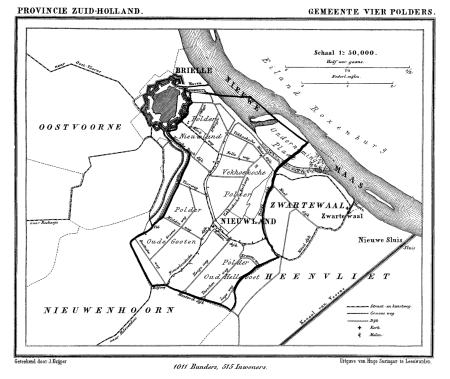
gemeente atlas van nederland - south holland
old maps of brielle
gemeente atlas van nederland - south holland
1860s maps of south holland
601 - 700 of 864
Next page
/ 9